Top Lists
Largest Earthquakes in the United States (Top 3)
Earthquakes, also known as shakes, happen when seismic waves produced by the lithosphere of the Earth as a result of an abrupt release of energy force the Earth’s surface to tremble.
The strength of earthquakes varies, with some being small and hardly noticeable while others are strong enough to cause substantial property damage and even fatalities.
A tsunami can be brought on by an offshore earthquake that moves the sea floor. Since the early 1700s, there have been hundreds of earthquakes in the US, the most of whose epicenters were located within its borders.
The term earthquake are used to describe any seismic event that produces seismic waves, whether it is caused by a natural disaster or human activity. Geological fault rupture is the main cause of earthquakes, but they can also be brought on by landslides, mine explosions, volcanic activity, and nuclear tests. The focal point, also known as the hypocenter, of an earthquake. The area just above the hypocenter at ground level is known as the epicenter.
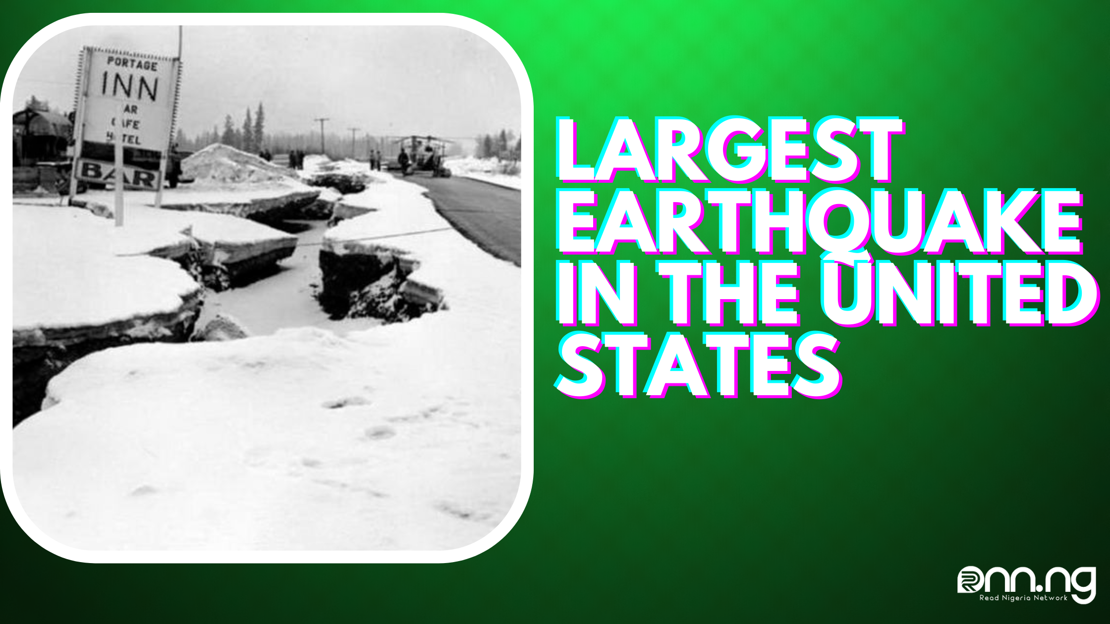
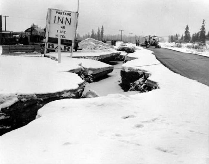
An earthquake of magnitude 9.2 struck the Alaskan region of Prince William Sound on March 27, 1964, at 5:36 p.m. local time (March 28, 3:36 UTC). With its epicenter at 6 miles (10 km) east of the mouth of College Fiord, 56 miles (90 km) west of Valdez, and 75 miles (120 km) east of Anchorage, the earthquake ruptured at a depth of about 25 km. The quake, which lasted for around 4.5 minutes, was the strongest ever recorded in the United States.
In addition, after the M9.5 earthquake in Chile in 1960, it is the second-largest earthquake ever to be recorded. The largest recorded earthquake in American history and the second-largest earthquake ever detected by modern instruments was the magnitude 9.2 Great Alaska Earthquake that shook south-central Alaska at 5:36 p.m. on Friday, March 27, 1964.
The majority of mainland Alaska felt the earthquake, as did Dutch Harbor in the Aleutian Islands, located 480 miles to the west. Seattle, Washington, located more than 1,200 miles to the southeast of the fault rupture, also felt it, and the Space Needle there noticeably swayed. As far away as the shores of Texas and Louisiana, rivers, lakes, and other waterways sloshed as a result of the earthquake. With the exception of Connecticut, Delaware, and Rhode Island, water-level recorders across 47 states—the entire nation—recorded the earthquake. Because of its size, the entire Earth was affected.
List of the Largest Earthquakes in the United States
The following is a list of some of the worst and most potent earthquakes in US history;
1. Great Alaskan Earthquake Alaska – March 27, 1964

Alaska experienced the highest strongest earthquake ever recorded in North America on March 27, 1964. The earthquake has been referred to as the Great Alaskan Earthquake, the Good Friday Earthquake, and the 1964 Alaskan earthquake.
An estimated 131 people were killed by the 9.2 magnitude earthquake that struck on Good Friday and lasted for 4 minutes, 38 seconds. It caused ground fractures, tsunamis, and the destruction of numerous buildings.
600 miles of a fault line suddenly collapsed, raising the land nearby by up to sixty feet and lowering it by up to eight feet in other places. In addition, the earthquake caused new fractures, infrastructural damage, and landslides.
The 1964 Alaskan earthquake is the second-strongest earthquake to ever be logged globally. The second-largest instrumentally recorded earthquake ever occurred on March 27, 1964, and it shook southern Alaska for four to five minutes.
Along with the earthquake, the incident also created a significant tsunami, which caused deaths and property damage from the Kodiak Islands to northern California. Together, the earthquake and following tsunamis resulted in 129 fatalities and estimated property losses of $2.3 billion (in 2013 dollars).
The majority of Alaska’s population, as well as its main thoroughfares, ports, and infrastructure, are located close to the area where the 1964 earthquake breached the eastern Aleutian Trench. The Great Alaska Earthquake produced a plethora of information regarding subductionzone earthquakes and the dangers they provide, albeit being terrible due to the loss of lives and property.
Over the past 50 years, earth science study has made significant advances because to the scientific breakthrough that came after the 1964 earthquake. This fact sheet honors the Great Alaska Earthquake and looks at how knowledge and technology advancements have improved earthquake readiness.
2. Washington, Oregon, and California – January 26, 1700

The earthquake that struck on January 26 is known as the 1700 Cascadia Earthquake, and it’s estimated magnitude ranged from 8.2 to 9.2, and it left devastation in the region that is now Washington, Oregon, and California.
The fact that the earthquake took place along the Cascadia Subduction zone gave rise to its name. The earthquake resulted in a tsunami off the coast of Japan and a 620-mile fault line rupture with an average slide of 66 feet. The amount of destruction and the number of casualties brought on by the Cascadia Earthquake in 1700 are not sufficiently known.
3. Alaska – February 4, 1965
Alaska experienced the 1965 Rat Islands earthquake nearly a year after the Good Friday quake. On Shemya Island, the 8.7-magnitude earthquake produced a tsunami that was 32 feet high. Records indicate that locations as far afield as Peru, California, Mexico, Russia, Japan, and Ecuador all felt the effects of the tsunami. The Alaskan-Aleutian megathrust, which separates the Pacific Plate from the North American Plate, is where the earthquake was generated.
Despite the earthquake’s strong magnitude, there were no reported fatalities and rather minor property damage. On Amchitka Island, however, tsunami flooding resulted in about $10,000 worth of damage.
However, there have been a number of additional earthquakes in Alaska that were stronger than 7.0. For instance, the magnitude 8.6 Aleutian Islands earthquake and tsunami on April 1, 1946, claimed 165 lives and significantly damaged property.
A magnitude 8.6 earthquake and tsunami struck the Andreanof Islands on March 9, 1957, although there were no confirmed casualties. The Denali earthquake, which struck Alaska on November 3, 2002, had a magnitude of 7.9 but no casualties.
Other earthquakes in Alaska include the 1958 Lituya Bay earthquakes and mega-tsunami, the 2014 Aleutian Islands earthquake with a magnitude of 7.9, and the 2018 Gulf of Alaska earthquake with a magnitude of 7.9. (magnitude 7.8, five fatalities). The earthquakes that struck California in 1857 at Fort Tejon and 1906 in San Francisco both were 7.9 in magnitude. The earthquake in 1857 only resulted in two fatalities, but the earthquake in 1906 resulted in more than 3,000 fatalities.
Below are the list of some of the other largest and biggest earthquakes in the United State not mentioned above;
| Rank | Location | Magnitude | Date | ||
| 1 | Prince William Sound, Alaska | 9.2 | March 28, 1964 | ||
| 2 | Cascadia Earthquake, Washington, Oregon California | 8.7-9.2 | 1700 | ||
| 3 | Rat Islands, Alaska | 8.7 | February 4, 1965 | ||
| 4 | Aleutian Islands earthquake and tsunami Alaska | 8.6 | 1946 & 1957 | ||
| 5 | New Madrid, Missouri | 7.9 | February 7, 1812 | ||
| 6 | Fort Tejon earthquake, California | 7.9 | January 9, 1857 | ||
| 7 |
|
7.9 | October 9, 1900 | ||
| 8 | Central Alaska | 7.9 | November 3, 2003 | ||
| 9 | Golf of Alaska | 7.9 | November 30, 1987 | ||
| 10 | Little Sitkin Island, Alaska | 7.9 | June 23, 2014 |
Read More:
Sources: Worldatlast, Infoplease, Usgs.gov